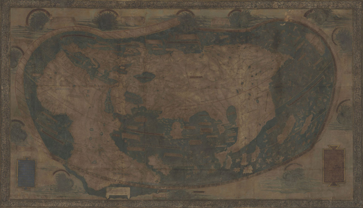
The map depicts the Earth’s surface from the Atlantic in the west to Japan in the east, is dotted with descriptions in Latin of various regions and peoples.
Henricus Martellus, a German cartographer working in Florence in the late 15th century, produced a highly detailed map of the known world. According to experts, there is strong evidence that Christopher Columbus studied this map and that it influenced his thinking before his fateful voyage. However, five centuries of fading and scuffing had rendered much of the map’s text and other details illegible or invisible, limiting its research value.
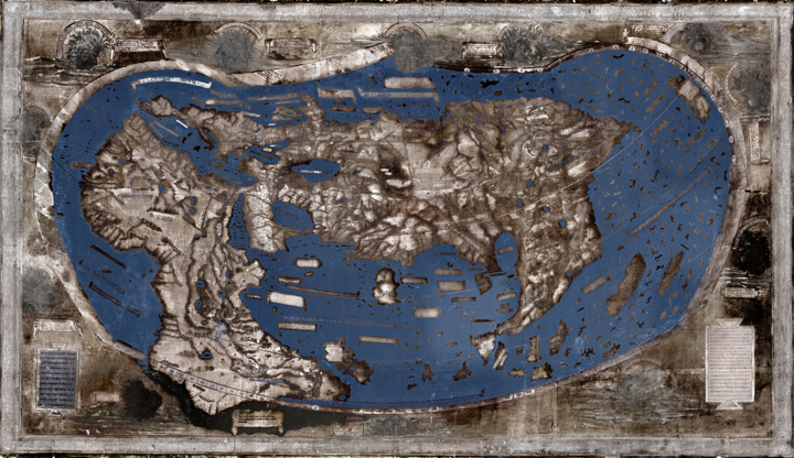
A team of researchers and imaging specialists is recovering the lost information through a multispectral-imaging project. Their work is yielding discoveries about how the world was viewed over 500 years ago.
“Perhaps the most interesting revelations, say the researchers, concern southern Africa. By studying visible river systems and legible place names, Van Duzer had previously determined that Martellus based his depiction of the region on the Egyptus N[MC1] ovelo [BL2] map, which survives in three manuscripts of Ptolemy’s “Geography.” The Egyptus Novelo used geographical data from native Africans, not European explorations. It is thought that the map was based on information shared by three Ethiopian delegates to the Council of Florence in 1441.
The new images show that the Martellus map’s depiction of southern Africa extends further east than the known versions of the Egyptus Novelo do, suggesting that the German cartographer was working from a more complete version of the map that showed the eastern reaches of the continent.
The lead researcher calls this a seminal and tremendously important document of African mapping by the people of Africa, in this case preserved by a western source.
View Source© 2026 Pixel Fable. All rights reserved.